


Photographing Capitol Reef National Park
Photographing Capitol Reef National Park
This park is another landscape photographers favorite.


Hi, I am Charlie Borland and welcome to my All About Photography newsletter. I have been a pro photographer for over 40 years and have a lot to share with you. Please join the photo adventure by subscribing to this reader-supported newsletter.
Photographing Capitol Reef National Park
Capitol Reef National Park in Utah is without a doubt one of my favorite parks to photograph and I have been there many times. This is not a park that is heavily overrun by people and photographers like Zion and Bryce. Yet, it offers a more diverse landscape for photography with some remote locations that are quite stunning.
The park is vast at 240,000 acres and it offers stunning scenery for outdoor photographers. I have yet to reach some of the furthest reaches of the park like the far southern end around the Halls Creek Narrows, but have photographed quite a few locations within the core area of the park. There are many great places to shoot and I haven’t shot them all, but these are a few of my favorite places to shoot:
Chimney Rock
You can't miss this location because it is right past the visitor center and next to the highway with a large parking area. You can get up close, or there are great angles from across the highway as well. And sunset is the best time.

4x5 Toyo field camera, 150mm lens, 4x5 Fujichrome film f/32 @ 1/8th.
The Fruita Community
This is the small historic Mormon community at the heart of Capitol Reef. The Fruita Historic District has been the home to humans for thousands of years. The community itself was built by Mormons in the 1800s and here you will find petroglyphs, a schoolhouse, historic motor vehicles, the old barn and rail fencing, and an old homestead.

4x5 Toyo field camera, 150mm lens, 4x5 Fujichrome film f/32 @ 1/8th.
The Fruita orchards turn wonderful colors in the fall and are right near the campground.

4x5 Toyo field camera, 210mm lens, 4x5 Fujichrome film f/45 @ 1/2 sec.
Hickman Bridge
A short hike from the Fruita community will bring you to Hickman Bridge and it is well worth the hike up there. I have found sunrise to be the better light and have shot it from multiple angles.

Canon 5D 17mm, f/22 @ 6 sec ISO 100
You can photograph the bridge from below and then hike up for an inside perspective.
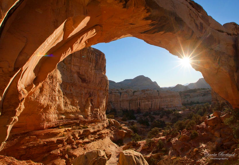
Canon 6D 17mm, f/22 @ 1/60th sec ISO 100
Capitol Gorge
The gorge can be reached off Scenic Drive where there is a parking lot and picnic area. From there you can follow the wash for several miles amongst the towering walls. There are rocks and formations and even petroglyphs to photograph.

Canon 5D 17mm, f/22 @ 6 sec ISO 100
South Draw area
South of Capitol Gorge is the South Draw area and I have driven that road before looking for scenes worth pulling out the camera. There are no points of interest on the map and here you have to just pull over and go hike. That is what I did here, just park and start hiking up and eventually, you will find scenes like this.

Pentax 6x7, Fujichrome film ISO 100, f/16 @ 1/60th
Strike Valley Overlook
This is the Waterpocket Fold and it is a unique geologic feature and it was captured from the Strike Vally Overlook. To get here you take the Bullfrog-Notom road just east of the park and head south. Drive until you reach the Burr Trail and then head east. NOTE: This is a 2WD road but the last time I was there years ago, it looked like a 4WD road. You must check with the local visitor area and confirm the conditions. As I write this, the road is impassible due to ice.
If you are enjoying this post, please share it.
Another option to avoid going uphill on the Burr Trail is to go the other direction starting in Boulder, UT. It is paved most of the way and is on top of the plateau and that means now 4x4 conditions.
There is a parking area on the north side of the road before you would go down the Burr Trail switchbacks to the valley. Park there and hike north through Muley Twist Canyon for an easy round trip of around 1/2 to 3/4 miles. This route allows you to avoid the Burr Trail.
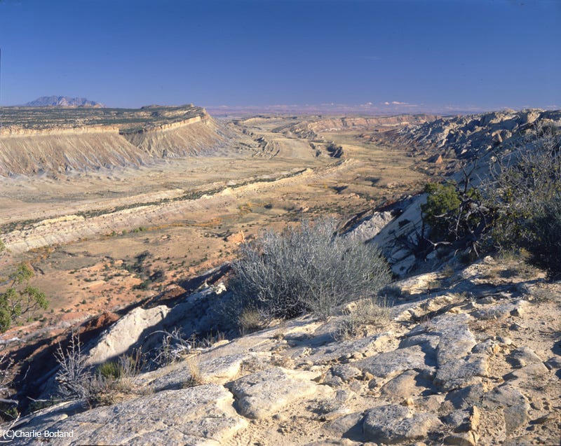
Waterpocket fold from STrike Valley Overlook
Panorama Point
Panorama Point is an excellent location for sunset with vast views of the park and you can zoom in some on the Henry Mountains as well.

Canon 5D 150mm, f/8 @ 1/25th, ISO 200
Sulphur Creek
This area has something different, what I call the Rock Field. It's a great sunrise area and is very close to the visitor center and campground. And I used my Nikon A2 warming filter.

5D 26mm lens, f/16 @ 1/8th, ISO 100
Slickrock Pass
Slickrock Pass is a divide that separates two drainages and is on the side of the Waterpocket Fold. It is reached off Scenic Drive and when you cross the pass, you can park and capture views like this. And it is another sunset location.

Canon 5D, 38mm lens, f/11 @ 1/80th, ISO 200
The Castle
This is a location right near the visitor center and easy to photograph. This is again, shot in the late afternoon during the fall. It is also on the park map as most locations in the post are. Why do I mention that?
If you are a stock photographer and shoot national park properties, the first thing you do when you arrive at a park is plan on shooting all locations on the park service map.
When magazines, for example, are planning to run a story on Capitol Reef, they will search for images of the main points of interest and those are usually shown on the park’s map. Capture those, but of course, capture your unique view of the park’s natural features, your own versions of one-of-a-kind images.
Subscribe and get these tutorials delivered to your Inbox.

Canon 5D 38mm lens, f/10 @ 1/50th, ISO 100
Cohab Canyon
This is a popular trail with interesting geology and photo ops. And the best part is that you can access it right from the campground. The trail is 1.56 miles one way and ends at Highway 24, or turn around and head back to the campground.

Cathedral Valley
The Cathedral Valley District of Capitol Reef National Park is a remote and rugged region. The landscape is unique due to its visual resemblance to the temples in Egypt and Gothic-style Cathedrals. The views are inspiring with monolith formations and vistas that are millions of years old.
The trip to the Cathedral Valley is a self-guided auto tour and is open to travel all year. Vehicles with high ground clearance, even those without four-wheel drive, can usually negotiate the roads without difficulty.
Having driven there before, I can verify one river crossing that your vehicle would have to navigate. It is not very wide and the water was around 10" deep when we went through it with our large 4x5 truck. But check at the visitor center to make sure your vehicle can cross. If it can, it will be worth the trip.
Subscribe and get these tutorials delivered to your Inbox.

Halls Creek Crossing
Hall Creek Crossing is a stunning location at the south end of the park, but has some challenges.

From the NPS website:
Along the way, hikers can explore numerous side canyons that join the Halls Creek drainage. At the remote southern tip of the park is the 3.8-mile (6.0 km) Halls Creek Narrows, deeply incised into the white Navajo sandstone. A perennial stream and shade from the arching canyon walls create an oasis in the midst of surrounding desert.
The route is largely unmarked; carrying a topographic map is recommended. The route is extremely hot in summer. Water can usually be found at the Fountain Tanks and in the narrows. Use caution in narrow canyons, particularly during the flash flood season (typically July-September). Hiking through the narrows requires wading through water that occasionally may be deep enough to require swimming.
Look up, look down, look all around!
Like everywhere, nature photographers wander in search of their best image capture ever, and this is where you photograph your own unique images of the natural world.
This photo is one of those. No specific location. I was wandering in search when I saw these ripples and thought those were interesting and worth capturing.
I posted this image on social media and asked randomly if anyone knew if the ripples were from water or wind. It was a lively debate and nobody agreed (of course) so these ripples are water or wind. That is all I could determine.

If you can make it to Capitol Reef, hopefully, this post will give you a starting point for photography. But don’t limit yourself to these locations. There are arches, slot canyons, vistas, and much more in the park. The landscape is diverse and varied and there is always something for the camera to frame no matter where you are.
If you are enjoying this post, please share it.
Be sure and check in at the visitor center for current conditions on trails and roads as well as water levels in creeks and rivers. It can be very hot in summer and pretty cold in winter. The rangers will be able to fill you in with the current information.
I hope you enjoyed this and if you have photographed there, please share your thoughts and even your images.
Keep shooting!
Thanks for reading. New Photography School is a huge commitment to produce so please join as a subscriber or patron, or take one of my streaming photography courses listed below. Your support would be greatly appreciated!
Support this Channel: Take a Photography Class

Online courses on Architecture and Real Estate Photography, Landscape & Nature, Professional Commercial Photography, Professional Nature Photography, Wireless Flash, and more.
Click HERE
Get the eBook
Super cheap like $6.99

Click HERE


Panorama Point… that photograph is just simply stunning beyond belief.
What a fascinating location! That photo at Panorama Point looks surreal!